Gilgit Baltistan, Pakistan borders province of Khyber Pakhtunkhwa to the west, Azad Kashmir to the southwest, Wakhan Corridor ofAfghanistan to the northwest, the Xinjiang Uyghur Autonomous Region of China to the north, and the Indian state of Jammu and Kashmir to the southeast.
Rock art and petroglyphs
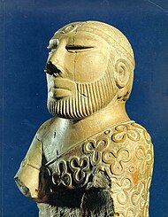
There are more than 50,000 pieces of rock art (petroglyphs) and inscriptions all along the Karakoram
Part of a series on the
| ||||||||||||||||||||||||||||||||||||||||||||||||||||
|---|---|---|---|---|---|---|---|---|---|---|---|---|---|---|---|---|---|---|---|---|---|---|---|---|---|---|---|---|---|---|---|---|---|---|---|---|---|---|---|---|---|---|---|---|---|---|---|---|---|---|---|---|
| History of Pakistan | ||||||||||||||||||||||||||||||||||||||||||||||||||||
 | ||||||||||||||||||||||||||||||||||||||||||||||||||||
BC
| ||||||||||||||||||||||||||||||||||||||||||||||||||||
| ||||||||||||||||||||||||||||||||||||||||||||||||||||
AD
| ||||||||||||||||||||||||||||||||||||||||||||||||||||
| ||||||||||||||||||||||||||||||||||||||||||||||||||||
| History of | ||||||||||||||||||||||||||||||||||||||||||||||||||||
| ||||||||||||||||||||||||||||||||||||||||||||||||||||
| Timeline | ||||||||||||||||||||||||||||||||||||||||||||||||||||
Highway in Gilgit Baltistan, concentrated at ten major sites between Hunza and Shatial. The carvings were left by various invaders, traders, and pilgrims who passed along the trade route, as well as by locals. The earliest date back to between 5000 and 1000 BCE, showing single animals, triangular men and hunting scenes in which the animals are larger than the hunters. These carvings were pecked into the rock with stone tools and are covered with a thick patina that proves their age. The ethnologist Karl Jettmar has pieced together the history of the area from various inscriptions and recorded his findings in Rock Carvings and Inscriptions in the Northern Areas of Pakistan[1]and the later released Between Gandhara and the Silk Roads - Rock Carvings Along the Karakoram Highway.[2] Many of these carvings and inscriptions will be inundated and/or destroyed when the planned Basha-Diamir dam is built and the Karakoram Highway widened.
End of the princely state
A pro-Pakistan rebellion, organised by a mutineered Major Brown of the Gilgit Scouts overthrew Ghansara Singh, the Governor administering the region on behalf of the Hindu Dogras, on November 1, 1947 and temporarily installed state of their own. Raja Shah Rais Khan became the President while Mirza Hassan Khan the Commander-in-Chief of the Gilgit scouts. The region had run its own government for 16 days but later, on the call of local residents unconditionally acceded to the newly established state of Pakistan.
British Raj
Before the independence of Pakistan and the partition of India, Maharaja Hari Singh, the Hindu Dogra ruler of Jammu, extended his rule to Gilgit and Baltistan with the help of British. In 1935 he leased the region to British for an amount of 75,000Rs. After WW IIBritish influence started declining. British despite decline in its rule, handled the situation cleverly and gave two options to the states in sub-continent under their rule to join any of the two emerging states, India and Pakistan. Taking advantage of the situation the populace of Gilgit-Baltistan started revolting, the people of Ghizer were first to raise the flag of revolution, and gradually the masses of entire region stood up against the rule of Mahraja, again British played an important role in war of independence of Gilgit-Baltistan. Finally it was on 1 November 1947 the people of Gilgit-Baltistan succeeded to get freedom, marking an end to the cruel Dogra Raj, and established an independent state which lived for a period of two weeks with a full-fledged government. It was on 16 November the newly born state of Gilgit-Baltistan decided to merge with Pakistan. Gilgit-Baltistan is still aligned with Pakistan as an independent and autonomous state, so far it is not a constitutional part of Pakistan.
Part of Pakistan
1947 to 1970 Government of Pakistan established Gilgit Agency and Baltistan Agency. In 1970 Northern areas council established by Zulfiqar Ali Bhutto and Gilgit Baltistan was directly administrated by federal government and it was called FANA(Federal administrated northern areas). In 1963, Pakistan ceded a part of Hunza-Gilgit called Raskam and the Shaksgam Valley of Baltistanregion to the China pending settlement of the dispute over Kashmir. This ceded area is also known as the Trans-Karakoram Tract. The Pakistani parts of Kashmir to the north and west of the cease-fire line established at the end of the Indo-Pakistani War of 1947, or the Line of Control as it later came to be called, were divided into the Northern Areas (72,971 km²) in the north and the Pakistani state of Azad Kashmir (13,297 km²) in the south. The name "Northern Areas" was first used by the United Nations to refer to the northern areas of Kashmir.[citation needed]
Gilgit Baltistan, which was most recently known as the Northern Areas, presently consists of seven districts, has a population approaching one million, has an area of approximately 28,000 square miles (73,000 km2), and shares borders with China, Afghanistan, and India.
The local Northern Light Infantry is the army unit that participated in the 1999 Kargil conflict. More than 500 soldiers were believed to have been killed and buried in the Northern Areas in that action.[6] Lalak Jan, a soldier from Yasin Valley, was awarded Pakistan's most prestigious medal, the Nishan-e-Haider, for his courageous actions during the Kargil conflict.
Self-governing status and present-day Gilgit Baltistan
On 29 August 2009, the Gilgit Baltistan Empowerment and Self-Governance Order, 2009, was passed by the Pakistani cabinet and later signed by the President of Pakistan. The order granted self-rule to the people of the former Northern Areas, now renamed Gilgit Baltistan, by creating, among other things, an elected legislative assembly. There has been some criticism and opposition to this move in India and Gilgit Baltistan region of Pakistan.[7][8]
Gilgit Baltistan United Movement while rejecting the new package demanded that an independent and autonomous legislative assembly for Gilgit Baltistan should be formed with the installation of local authoritative government as per the UNCIP resolutions, where the people of Gilgit Baltistan will elect their president and the prime minister.[9]
In early September 2009, Pakistan signed an agreement with the People's Republic of China for a mega energy project in Gilgit–Baltistan which includes the construction of a 7,000-megawatt dam at Bunji in the Astore District.[10] This also resulted in protest from India, although Indian concerns were immediately rejected by Pakistan, which claimed that the Government of India has no locus standi in the matter, effectively ignoring the validity of the princely state's Instrument of Accession on October 26, 1947.
On 29 September 2009, the Prime Minister, while addressing a huge gathering in Gilgit–Baltistan, announced a multi-billion rupee development package aimed at the socio-economic uplifting of people in the area. Development projects will include the areas of education, health, agriculture, tourism and the basic needs of life.


0 Comments